This thread has been locked.

If you have a related question, please click the "Ask a related question" button in the top right corner. The newly created question will be automatically linked to this question.

IWR6843ISK-ODS: IWR6843 ODS 3d point cloud extraction

Part Number: IWR6843ISK-ODS
Other Parts Discussed in Thread: DCA1000EVM,


Hello, Ti. 

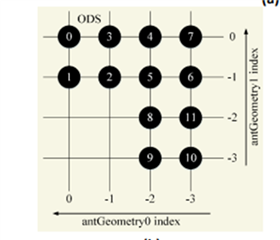
I am using DCA1000EVM + IWR6843ISK-ODS radar to extract 3d point cloud data. Using DCA1000EVM we are able to get rawdata from radar and we are using matlab to process the raw data. 

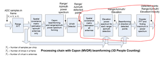
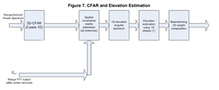
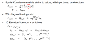
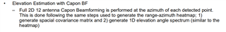
I am able to get range-doppler, range-azimuth map, but the problem that i'm having is getting elevation using capon algorithm. 

So I'm trying to refer to pages 13 to 15 of the guide below, but I don't understand the formula completely. 

Is there sample code that i can refer to? 

https://www.ti.com/lit/ug/tidue71d/tidue71d.pdf?ts=1626807808928&ref_url=https%253A%252F%252Fwww.google.com%252F

  • Hi,

    The 3D People Counting Code on the device is the only code we have for this. You may also find the PDF documents here helpful.

    https://dev.ti.com/tirex/explore/node?a=1AslXXD__1.00.01.07&node=A__AMH81pbICLF3ScBRW5hxsA__radar_toolbox__1AslXXD__1.00.01.07&r=1AslXXD__1.00.00.26

    Best,

    Nate

  • I am now referring to the guide you provided, but I'm not sure yet, so I'll ask the question again.

    According to the People Tracking and Counting Reference Design guide, the overall detection direction is as follows.is as follows.

    I have a question about the part marked in red in the processing chain in the picture.

    More details are organized on pages 12 and 13 of the guide, and I have a few questions here.

    1. Xkcr is the clutter removed signal. So, the corresponding data is 3-dimensional data, rangebin x chirp no x virtual antenna (using 12), so the data is 3-dimensional data, ram I right??
    2. To obtain the elevation, the capon algorithm that first obtains the range angle map is used. Through the covarince matrix, a two-dimensional array of range/azimuth specturm Pna is formed. Here, the target distance and azimuth angle are extracted through cfar. I know. However, if you look at the elevation processing chain, it says that it calculates the spatial covariance matrix, but I don't understand how to get the covariance matrix of the detected points.
    3. This is a question related to number 2, and the process is summarized as a formula on page 13 as follows

               Here Xkc is what shape does the matrix have? And I don't understand where the location information of the target detected through cfar is used. Xkc             is 3-dimensional data, isn't it 3-dimensional data consisting of range bin x chirp number x virtual antenna? Angle information is not included in this               signal. How is the result detected in the range azimuth map used? Are only distance values ​​used for elevation measurements?

    1. It seems that 4 virtual antennas are used for azimuth calculation, but why are 12 antennas used for elevation estimation? If the ods model is used for the elevation antenna, the following virtual antenna is formed. Aren't there a total of 4 antennas that can be used for elevation?

  • Xkcr is the clutter removed signal. So, the corresponding data is 3-dimensional data, rangebin x chirp no x virtual antenna (using 12), so the data is 3-dimensional data, ram I right??

    The cluttered-removed signal is still three dimensional yes.

    • To obtain the elevation, the capon algorithm that first obtains the range angle map is used. Through the covarince matrix, a two-dimensional array of range/azimuth specturm Pna is formed. Here, the target distance and azimuth angle are extracted through cfar. I know. However, if you look at the elevation processing chain, it says that it calculates the spatial covariance matrix, but I don't understand how to get the covariance matrix of the detected points.

    The covariance matrix of the detected points is created by taking the outer product of the data at a single range/azimuth location over all the different elevation antennas. This will yield the covariance in the elevation direction.

               Here Xkc is what shape does the matrix have? And I don't understand where the location information of the target detected through cfar is used. Xkc             is 3-dimensional data, isn't it 3-dimensional data consisting of range bin x chirp number x virtual antenna? Angle information is not included in this               signal. How is the result detected in the range azimuth map used? Are only distance values ​​used for elevation measurements?

    I would expect X_kc, as the input to the elevation estimation, to be a 4x4 matrix that corresponds to the a single range and azimuth bin over the 4 elevation antennas. The location information of the target through cfar is used so we don't calculate the elevation spectra for every single range/azimuth location, just the ones that have been identified through CFAR. I don't believe this would be used for the range/azimuth map. The elevation measurements use the difference in returns over different antennas placed at different elevations to estimation the target elevation. 

    1. It seems that 4 virtual antennas are used for azimuth calculation, but why are 12 antennas used for elevation estimation? If the ods model is used for the elevation antenna, the following virtual antenna is formed. Aren't there a total of 4 antennas that can be used for elevation?

    The antennas are only placed with 4 in different azimuth and 4 in different elevation positions.

  • Thank you for the answers. I understood the questions 1 and 4, and the question I had before question 2 still not resolved. The way I understand the elevation spectrum is estimated is blow The way I understand the elevation spectrum is calculated as follows.

    If Pd is one point detected through CFAR, the range bin and azimuth angle will be specified as one. And chirp is average when we estimate azimuth spectrum. If that's the case, wouldn't it be possible to use the number of chirps when calculating the elevation spectrum? How come Xkc is 4 x 4?

  • I am not sure what you're asking here. Is X_kc the same as X_kcr? The covariance of the elevation estimate is 4x4 because we have 4 antennas in the elevation domain.

    Best,

    Nate

  • I think my explanation was lacking. I'll make up for it and ask you three questions

    1. Do Pna circled in red and range/azimuth power spectrum mean the same thing? Then the shape of Pna is (range x azimuth spectrum), right?
    2. If cfar is used in the range/azimuth power spectrum, one value for azimuth and one range comes out. Are azimuth and range points also utilized to obtain the elevation spectrum here?
    3. It is said that a covariance matrix is ​​obtained based on the results of Xkcr and cfar with black squares. Xkcr is (virtual antenna x range bin x chirp no) 3d matrix. So, I know that the range point resulting from the cfar should be put in the range bin of the 3d matrix, but where do you put the azimuth point to find the covariance?
    • Do Pna circled in red and range/azimuth power spectrum mean the same thing? Then the shape of Pna is (range x azimuth spectrum), right?

    Yes I believe so. See figure 3 for a full diagram.

    If cfar is used in the range/azimuth power spectrum, one value for azimuth and one range comes out. Are azimuth and range points also utilized to obtain the elevation spectrum here?

    The elevation spectrum must be generated by holding the range/azimuth constant. 

    It is said that a covariance matrix is ​​obtained based on the results of Xkcr and cfar with black squares. Xkcr is (virtual antenna x range bin x chirp no) 3d matrix. So, I know that the range point resulting from the cfar should be put in the range bin of the 3d matrix, but where do you put the azimuth point to find the covariance?

    The azimuth is held constant as well. This is what is meant by "performed at the azimuth of each detected point"

    Best,

    Nate