Other Parts Discussed in Thread: IWR6843ISK-ODS
Hi
I went through the Industrial Visualizer src code but couldn't find the equation for obtaining the AzimuthResolution and ElevationResolution.
Please provide the necessary resources.
Regards
Aditya
This thread has been locked.
If you have a related question, please click the "Ask a related question" button in the top right corner. The newly created question will be automatically linked to this question.
Hi
I went through the Industrial Visualizer src code but couldn't find the equation for obtaining the AzimuthResolution and ElevationResolution.
Please provide the necessary resources.
Regards
Aditya
Hi Aditya,
The azimuth and elevation resolution is primarily a result of the antenna pattern. See the documentation: https://dev.ti.com/tirex/explore/node?a=1AslXXD__1.10.00.13&node=A__ACvJLhyw8rRPopsPFMtIWw__radar_toolbox__1AslXXD__1.10.00.13
Regards,
Tim
Hi Tim
That seems to be a max resolution.
I am looking for the fundamental equation that gives the resolution as per the antenna's enabled configuration.
Regards
Aditya
Hi Aditya,
You are correct. That page shows resolution based on having all RX/TX enabled for the specific device. If you are disabling a TX for example, that may change. Please check out this application note to further understand how that will effect your resolution.
Regards,
Tim
Hi
I went through the docx, and it was really helpful in understanding the effect of antennas on resolution. However, I am still puzzled about how to obtain the resolution for a particular antenna mask selection.
Pleas provide some insights into this.
Regards
Aditya
Hi Aditya,
The introduction of that document explains "The angle resolution of a SIMO radar depends on the number of RX antennas. For example, a device with four RX antennas has an angle resolution of about 30º, while a device with eight RX antennas has an angle resolution of about 15º."
Thus, to obtain the resolution for a particular mask selection, you will have to follow the process outlined in that document to determine the total number of equivalent "virtual" RX antennas. From there it is the simple calculation above.
Regards,
Tim
Hi Tim
I want to know how the equivalent virtual antennas are calculated for elevation and azimuth resolution.
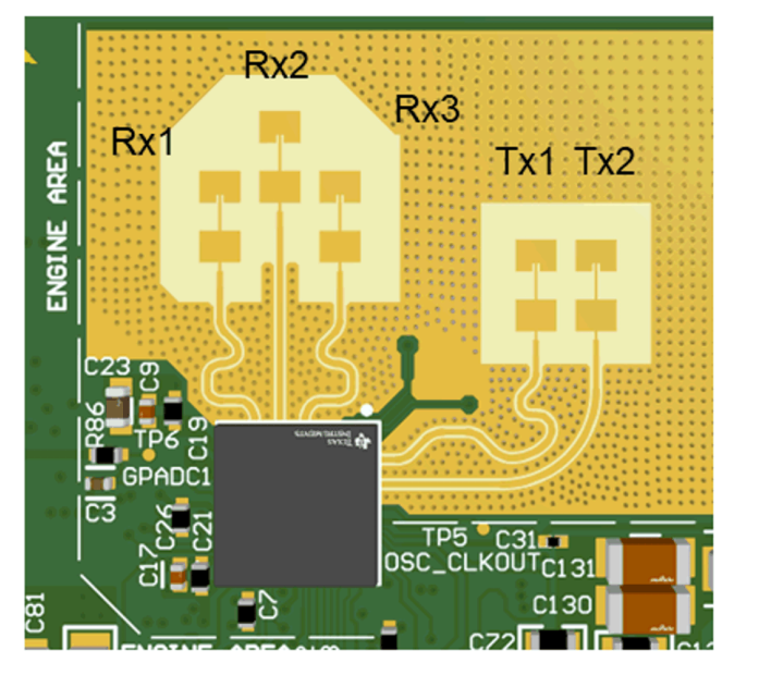
Like is it, for elevation, we consider only Rx2 and TX1 and Tx2, and based upon selection, we calc virtual antennas,
and for azimuth , we consider only Rx1 , Rx3 and Tx1 ,Tx2, and based upon selection we calc virtual antennas,
Is my understanding correct?
Regards
Aditya
Hi Aditya,
Sorry for the delay, I will get back to you within 24 hours.
Regards,
Tim
Hi,
I suggest you read the antenna app-note in more detail that I posted earlier. The azimuth resolution would be dependent on all 3 RX antennas and both TX antennas. For elevation, it would be dependent on RX1 and RX2 or RX3 and RX2.
So for example, you could disable RX1 and still maintain the same elevation resolution, though your azimuth resolution would suffer.
Regards,
Tim
Hi,
Can you provide the antennas app note?
The one provided earlier doesn't provide any info for elevation and azimuthal resolution for virtual antennas calculation.
I didn't understand your inference
Even if RX1 is disabled how it maintain the same elevation resolution?
Why azimuthal resolution depends on rx2.
From the imagae we can see rx2 is having an elevation in comparison to other rx
I want to know the logic of how the antennas are identified whoch have azimuthal resolution dependency or elevation resolution dependency?
Also, the elevation resolution depends on both tx, correct?
Hi
If Azimuth is dependent on all 3 RX antennas and both TX antennas.
Then ThetaRes=2/N=2/(6) equivalent to 19.0986 degree and not 29 as written in the docx
But if we consider If Azimuth depends on all 2 RX antennas(1 and 3)and both TX antennas.
Then ThetaRes=2/N=2/(4) equivalent to 29 degrees, as written in the docx
Hi
If Elevation is dependent on RX1 and RX2 or RX3 and RX2.
Does that mean, for elevation resolution calculation it considers only 1 TX antennas for virtual antennas calculation
Then ThetaRes=2/N=2/(2) [2rx,1 tx] equivalent to 58 degree ,as written in the docx
If you tell me how the azimuth and elevation angle is calculated for 3.7 IWR6843ISK-ODS Antenna, it will be helpful.

Hi Aditya,
Sorry for the delayed response. See this page to visualize the virtual antenna array of the ODS device.
For that we can do 120* FOV / 4 RX antennas in both directions to get the 30* resolution figures in both azimuth and elevation. I imagine there are some other factors like material etc. that make the actual resolution 29* as stated on that page.
Does this help?
Regards,
Tim
How the virtual antennas are calculated for both azimuthal and elevation, please explain, which combination is taken(tx ,rx) to get best mentioned resolution in azt and elev.,for calculation of virtual antennas, using theta =2/N
This is is in regard to ODS.
Hi Aditya,
The calculation of virtual antennas for ODS can be found in the paper as well as the antenna patterns page. Both of which I have linked above.
This forum is meant for debugging of our sensor devices and less so for theory. I am going to close this thread.
Regards,
Tim