Other Parts Discussed in Thread: IWR6843
Hi,
I have set up my stand alone IWR6843 AOP sensor with 3D people tracking demo.
I am sending the following configurations to the chip (This is the same cfg file present in the demo):
As you can see, the field of view is set up as 140 azimuth and 140 elevation.
I get the following frame after I run the sensor :
02 01 04 03 06 05 08 07 04 00 05 03 80 02 00 00
43 68 0A 00 AA 00 00 00 00 00 00 00 2C 00 00 00
05 00 00 00 00 00 00 00 FC 03 00 00 74 01 00 00
0A D7 23 3C 0A D7 23 3C F7 CC 92 39 6F 12 83 39
0A D7 23 3D F7 8A 00 00 ED 05 F1 03 07 8B 00 00
EA 06 C6 1E 07 8B 00 00 E7 07 C6 37 FF 8B 00 00
E4 08 74 26 F7 8D 00 00 ED 05 EE 03 07 8D 00 00
EA 06 20 1B 07 8D 00 00 E7 07 51 2F FF 8E 00 00
E4 08 31 21 FB 90 00 00 ED 05 EB 03 07 90 00 00
EA 06 28 18 07 90 00 00 E7 07 C2 28 FF 90 00 00
E4 08 FB 1C FF 92 00 00 ED 05 EE 03 07 92 00 00
EA 06 BE 15 0B 91 00 00 E7 07 A2 23 FF 92 00 00
E4 08 96 19 FF 95 00 00 ED 05 F1 03 0B 93 00 00
EA 06 D0 13 0B 93 00 00 E7 07 9E 1F FF 95 00 00
E4 08 D7 16 FF 97 00 00 ED 05 F5 03 0B 96 00 00
EA 06 46 12 0B 96 00 00 E7 07 6E 1C FF 97 00 00
E4 08 98 14 03 99 00 00 ED 05 FB 03 0B 98 00 00
EA 06 11 11 0B 98 00 00 E7 07 EA 19 FF 99 00 00
E4 08 BD 12 03 9B 00 00 ED 05 04 04 0B 9A 00 00
EA 06 23 10 0B 9A 00 00 E7 07 EA 17 FF 9B 00 00
E4 08 33 11 03 9C 00 00 ED 05 0E 04 0B 9C 00 00
EA 06 6E 0F 0B 9C 00 00 E7 07 57 16 FF 9C 00 00
E4 08 EB 0F 03 9E 00 00 ED 05 1A 04 0B 9D 00 00
EA 06 EE 0E 0B 9D 00 00 E7 07 18 15 03 A0 00 00
ED 05 2A 04 0B 9F 00 00 EA 06 96 0E FF A7 00 00
B3 18 8D 00 07 AD 00 00 B0 19 D5 00 F3 B2 00 00
AC 1A 07 01 F2 03 00 00 70 00 00 00 00 00 00 00
7A 14 BD BE CA A8 DD 3E B7 1E E4 3D 37 C0 89 3D
A1 81 65 3E B5 D4 6E 3D 26 AC 17 BE 83 F9 04 BE
08 AA 29 BF A4 68 90 3F 9E 81 B0 BC 70 DC 8A BC
00 A5 A2 BB 9E 81 B0 BC 06 CF 69 3F EC 8C 03 BD
F3 FD 0C BC 70 DC 8A BC EC 8C 03 BD 47 79 69 3F
F8 0F D1 BB 00 A5 A2 BB F3 FD 0C BC F8 0F D1 BB
75 AB 8D 3E 00 00 40 40 D7 35 79 3F F4 03 00 00
0C 00 00 00 00 00 00 00 0C DF 8C 3F 5E A8 77 3F
F3 03 00 00 1F 00 00 00 00 00 00 00 00 00 00 00
00 00 00 00 00 FF 00 00 00 00 00 00 00 00 00 00
00 00 00 00 00 00 FF FD 03 00 00 04 00 00 00 01
00 00 00 BE BE BE BE BE BE BE BE BE BE BE BE BE
BE BE BE 00 00 00 00 00 00 00 00 00 00 00 00 00
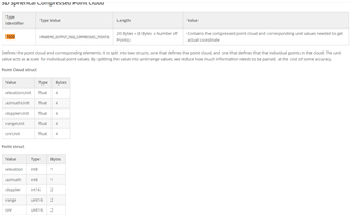
If you view the first point received in the 3D point cloud we get the following data:
TLV type found: 1020
Databytes: 372
TLV header stored.TLV :1020
TLV header stored.len :372
[ elevationUnit: 0.010000
azimuthUnit: 0.010000
dopplerUnit: 0.000280
rangeUnit: 0.000250
SNRUnit: 0.040000 ]
___________
[ elevation mul: 247
azimuth mul : 138
doppler mul : 0
range mul : 1517
snr mul : 1009
]
3D point: 0
[
elevation (rads): 2.470000
azimuth (rads): 1.380000
doppler (m/s): 0.000000
range (m): 0.379250
SNR : 10.090000 ]
As you can see, the elevation in radians is 2.47 which is way more than +70_ -70 fov sent in the cfg.
I wanted to know if this is an error in the sensor or my method of data extraction is incorrect?


