This thread has been locked.

If you have a related question, please click the "Ask a related question" button in the top right corner. The newly created question will be automatically linked to this question.

IWR1443BOOST: Perform tracking with IWR1443

Part Number: IWR1443BOOST
Other Parts Discussed in Thread: IWR1443, IWR6843, IWR1642

Hello,

I'd like to perform tracking of object with an IWR1443, because it has elevation measurement (and because my IWR6843 doesn't work for the moment to do it).

Here is my first question:

  • I have not seen tracking done with IWR1443 in Labs, is it possible ?

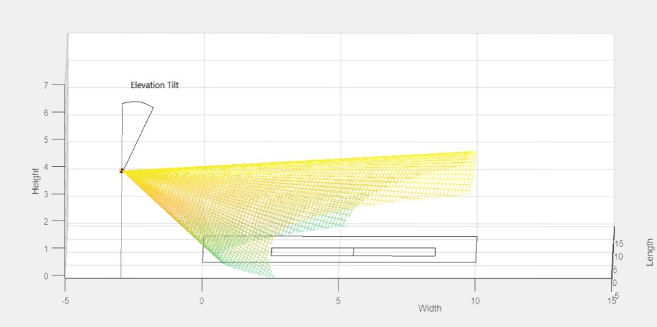
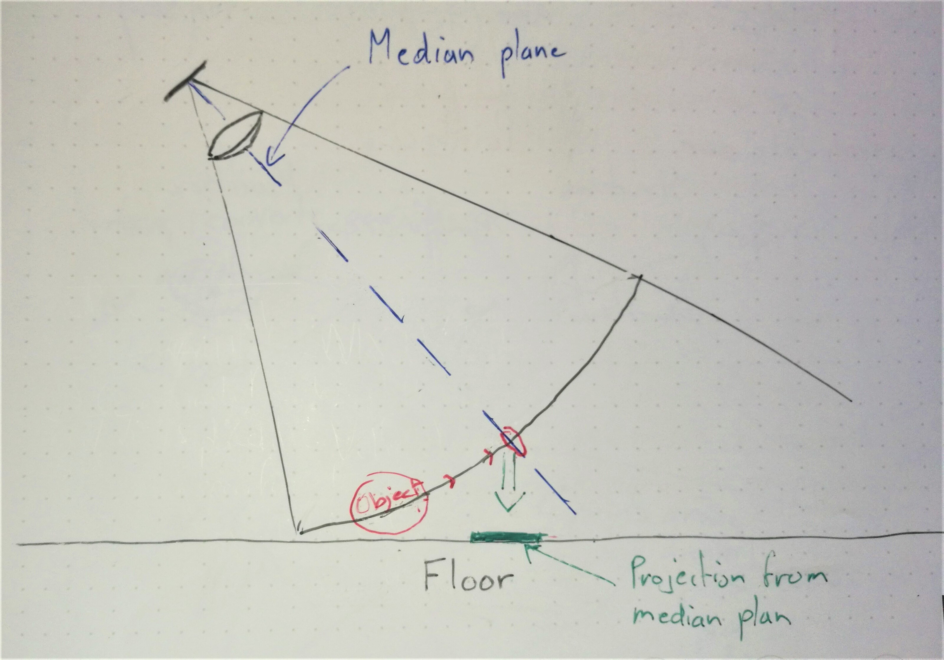
In my use case the mmwave sensor must be a few meters above the floor and track object moving on the floor. If I want to "see" those objects I have to put an Elevation Tilt (around 30°). But with this tilt, I will need the Z Data to compute the exact position of my targets on the floor depending of E. Tilt. So here is my second question (without regarding of the model) :

  • Does the tracking can be done with 3D point cloud ? If so, I'll have to create the GUI to visualize those data and the tracking ?

Last question, about Elevation TIlt:

  • How can I tell the sensor that there is an Azimuth AND an Elevation Tilt ? Where (mmWaveDevice or GUI) this computation  of coordinates on the floor must be computed ?

Sorry if I'm not clear, I'll add a picture of my GUI to help you understand my use case if needed.

Thanks for your help !

Quentin.

  • Hi Quentin,

    Thank you for your question. I'll need to talk to my team about this and get back to you. Please allow a few days for a response.


    Cheers,
    Akash
  • Hi Akash,

    Sure ! If you need more precisions, feel free to ask.

    Here is the display I have created according to my use case to see the targets :

    Have a nice day !

    Quentin.

  • Hi Quentin,

    Tracking has been implemented on our IWR1642/IWR6843 devices via the on-chip DSP. Unfortunately the IWR1443 does not posses this DSP and no native tracking algorithms are available at present.

    It is definitely possible to track points in the 3D point cloud, it is a feature you will need to add to the existing visualizer code. I'd recommend starting with the existing Zone Occupancy Lab and implementing a similar tracking features as is used in the People Counting Lab.

    Lastly, the elevation tilt is fixed at about 10~30 degrees but the azimuth tilt is configured with how you set up your scene. i.e. this is performed when you list the distances to different walls and the direction of your sensor directly in the gui itself.

    Let me know if you have more questions.


    Cheers,
    Akash
  • Hi Akash,

    Thanks a lot for your answers !

    Ok, so If I use IWR1443 I'll have to export datas to perform tracking on an other hardware.

    Actually, I have to manage 3D Point Cloud to get the exact position of the object (because of the elevation tilt; if I don't use it, the projection from the median plan to the floor will have an error). Here is a little draw to illustrate it : (sorry drawing is not one of my hobbies !)

    But if I can achieve a projection on a plan parallel to the floor, then I could use the 2D tracking with those good projection !

    So I'll begin with Area Scanner Lab (because IWR6843 has a DSP) to know where I could get this 3D Pointcloud.

    I don't understand very well what do you mean by

    Akash Gondalia said:
    the elevation tilt is fixed at about 10~30 degrees
    . Is the elevation tilt hard written from 10 to 30° (depending on the Lab) ?

    Could it be possible to get it from configuration file or from GUI like Azimuth Tilt ?

    Thanks again for your help,

    Have a great day !

    Quentin.

  • Hi Quentin,

    I think your drawing looks great! Let us know how results look with the Area Scanner Lab.

    The Elevation tilt is fixed because the on-board antenna has an elevation field of view of +/- 15 degrees (so 30 total). If you want to tilt the sensor more or less then you are going to compromise your detection range in one direction or another.

    Again this is a physical limitation so it cannot be corrected through software.


    Cheers,
    Akash
  • Hi Akash,

    Thanks ! Sure, I'll begin to add a new CLI to input coordinates of the radar (X,Y,Z,Azi. angle, Ele. angle) in my area, then I'll compute data in my area basis (and not in the sensor one) and finally I'll project those 3D points on the "floor" to apply 2D tracking !

     I understand, I'll lose in range but because I have to monitor object on the floor from few meters high I think I have no choice. Maybe with an other radar with a bigger cone I could mount it overhead to monitor objects without computing from elevation angle! But that's not possible currently.

    Thanks for all your answers,

    Have a nice day !

    Quentin