This thread has been locked.

If you have a related question, please click the "Ask a related question" button in the top right corner. The newly created question will be automatically linked to this question.

IWR6843ISK-ODS: Why is invRn for azimuth estimation is 4x4 and invRn for elevation estimation 12x12?

Part Number: IWR6843ISK-ODS


Hi,

I am reading 3D people counting lab's FW source code and I have a question about azimuth and elevation estimation processes.

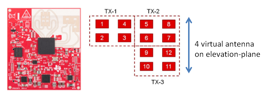
In order to use capon algorithm for azimuth and elevation estimations, it is making invRn matrices respectively.

For azimuth estimation, the invRn size is 4x4, using #0/3/4/7 virtual antenna signals.

On the other hand, for elevation estimation, the invRn size is 12x12, using #0/1/2/3/4/5/6/7/8/9/10/11 virtual antenna signals.

Regarding the layout of antenna on IWR6843ISK-ODS, I think the size of invRn for elevation estimation will also be 4x4(virtual antenna :#4/5/8/9).

What makes this difference between 4x4 and 12x12?

Best regards,

Fields

  • Hi Fields,

    The first Capon AoA function is used to generate a range-azimuth heatmap. When using the ODS board, the azimuth plane has 4 virtual antenna symbols. To maximize speed, we only consider the 4 symbols that we care about, then generate the heatmap with those. The invRn matrix will be NxN, where N is the number of Virtual Rx symbols. 

    Once a point is detected, we want to determine elevation and azimuth for the point. Regardless of EVM (ISK or ODS) we want to use all 12 virtual Rx symbols for this, so the invRn matrix becomes 12x12.

    Regards,

    Justin

  • Hi Justin,

    According to what you said, I understood that the first capon process(azimuth estimation)  has to save processing time since it has to do calculations for all the range and azimuth bins to create heatmap, while the second capon process(elevation estimation) gives priority to angle estimation accuracy over processing time since it does calculations only for detected range and azimuth bin.

    Am I correct?

    If I am correct, now I wonder why 12 virtual antenna make better accuracy in angle estimation than using 4 virtual antenna.

    Even if it uses 12 virtual antenna, it doesn't increase the number of virtual antenna on the elevation plane, does it?

    For example, how is it different in elevation estimation accuracy between using [#8, 7, 12, 11] virtual antenna and using [#5, 8, 7, 12, 11] virtual antenna?

    Best regards,

    Fields

  • Hi Fields,

    Theoretically, the accuracy in elevation (or azimuth) is the same if we use 4 Antennas in a row. By using multiple rows of antennas, we can average out some of the noise.  However, the reason to take this approach is to ensure that we place the points in the right location. As you know, detection is in this order:

    1. Range-Azimuth Heatmap
    2. CFAR on 1
    3. Elevation detection for each point.

    Because detection is range-azimuth, we can get more than one point at each range bin. So if we just do an elevation search at that range bin, how do we ensure that we associate the correct elevation with the correct azimuth? The solution is to do a 2D Capon heatmap generation (Azimuth and elevation are the two dimensions), then do a peak search. That peak will have azimuth and elevation; the azimuth value should match the one obtained in the CFAR step.

    Regards,

    Justin