This thread has been locked.

If you have a related question, please click the "Ask a related question" button in the top right corner. The newly created question will be automatically linked to this question.

TIDEP-01012: MIMO - Angular Resolution

Part Number: TIDEP-01012

Dear sir or madam,

we did some experiments with our TIDEP-01012 (Rev. C) and we are confused regarding the angular resolution. The Sensor Reference Design (Link) indicates in table 1 (Key System Specifications) on page 4 that the MIMO-Settings have an Azimuth Angle Resolution of 1.4 degrees. However, when plotting a map of a MIMO-acquisition, we seem to have a much higher angular resolution within the previously specified range of about +/-60° (Link) or +/-70° as mentioned in the Sensor Reference Design. However, 1.4° is roughly achieved at about +/-70°. Did you therefore specify the angular resolution based on this threshold and the angular resolution is indeed much better between +/-40°?

Thank you very much for your help and best regards,

Andreas

Fig. 1: Angles received from asin(sine_theta) * 180/pi in plot_range.azimuth_2D.m

Fig. 2: Computed angular differences with a range of 0.4476° to 7.1666°.


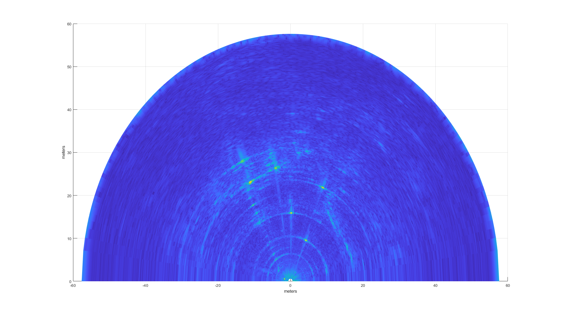
Fig. 3: Example acquisition.

  • hi,

    Angular Resolution will depend on the angle as described in the MIMO Radar Appnote

    The cascade team will review your question and get back to you before end of the week

    thank you

    Cesar

  • Angle resolution is a function of arriving angle in general, see Appendix in the above attached document. The 1.4 degree is quoted for angle resolution at boresight (theta = 0). 2/86*180/pi = 1. 4 degrees. Note that although there are 192 virtual channels, there are a lot of overlap virtual channels. The effective aperture size is 86 virtual channels. That's why 86 is used to calculate the angle resolution at the boresight.

  • Dear Dan Wang and Cesar,

    thank you for your fast reply. This answers now how the 1.4 degrees have been computed. However, when i see the results produced by the Matlab-Code provided by Texas Instruments i can not find this 1.4 degrees. The resolution at azimuth = 0 degree (boresight) seems to be 0.45 degree (see Fig. 2 above) and not 1.4 degrees. Is there any further internal processing involved that the resolution is so much better or how can this be explained?

    If I have a look on the formula used in the plotting function, which has been provided, you compute the X/Y coordinates based on the following formulas:

    sine_theta = -2*((-n_angle_fft_size/2:n_angle_fft_size/2)/n_angle_fft_size)/d;

    cos_theta = sqrt(1-sine_theta.^2);

    [R_mat, sine_theta_mat] = meshgrid(indices_1D*range_resolution,sine_theta);

    [~, cos_theta_mat] = meshgrid(indices_1D,cos_theta); 

    x_axis = R_mat.*cos_theta_mat;

    y_axis = R_mat.*sine_theta_mat;

    with n_angle_fft_size = 256 and d=1, which leads to SIN(Theta) = -2 * [-128:1:128] / 256 = [1...-1] and using theta = arcsin(..) and subtracting theta(i) - theta(i-1) for i = 2:257 I receive the values plotted in Figure 2 (above), which have much smaller angles than the declared 1.4°.

    Do you have any explanation for it?

    Best regards,

    Andreas

  • The number you quoted is not angle resolution. It is FFT bin width. Angle resolution is fundamentally determined by radar aperture size. FFT bin width is determined by the FFT size. The larger the FFT size, the finer the bin width.

    Angle resolution and FFT bin width are two different concepts.