Other Parts Discussed in Thread: TIDA-020047, AWR2243
Hello,
We used profile configuration from the application report (SWRA574B) and we found the results (point clouds) aren't coherent.
We started debugging to found the root cause and we found that the antenna geometry structure which defines our antenna is not used in any step of data processing.
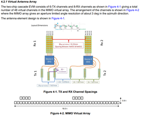
How could we configure the processing chain to indicate that the second TX antenna is used for elevation and the other for azimuth.(because with cascading we have now 6 TX (5 azimuth and 1 elevation) and 8 RX) ?
Thanks.